
This summer, the Davis Center's Imperiia team partnered with the Harvard Map Collection on the “Undoing Empire” project. The project was awarded a Harvard Library Advancing Open Knowledge grant to sustain work across a six-month period. It has three goals: 1) create a database of biodiversity in 19th-century Ukraine, 2) create an inclusive strategy for mapping historical places, and 3) develop best practices for producing data that can be preserved via the Harvard Geospatial Library and the Harvard Library (HOLLIS) catalog.
The partnership is a natural one. At the Map Collection, librarians Belle Lipton and Marc McGee want to encourage researchers to produce high-quality spatial data, while the Imperiia team wants the spatial data we produce to be discovered and used. Together, we are addressing a common problem in digital scholarship: Most researcher-generated datasets, which are built from a variety of archival and other materials, are not preserved for the long term in open-access library systems. Even in cases where datasets are discoverable, they are frequently missing important contextual information, such as detailed source citations or descriptions of the methods used to convert those sources into data. These problems make it nearly impossible for others to make sense of — let alone use — these pieces of scholarship.
If a book needs great footnotes, a dataset needs great metadata. Most researchers will tell you that composing either one is anticlimactic at best and tedious at worst. But what if we reinvented the documentation of decision-making? What if we found a way to streamline the production of metadata? What if we developed a model for productive collaboration between researchers and librarians? What if we built real — possibly entertaining — human conversation into the process?
To that end, we are testing workflows, documenting practices, designing interview questions, and generally attempting to smooth the path from inception to publication of spatial data. We are finding that as important as it is to iterate on a data model, the best way to produce valuable data is to sit down and talk with other stakeholders.
But this project is also about the content. The cost of Russia’s war against Ukraine is high, whether calculated in terms of the loss of human life, cultural heritage, or landscape. In the face of all that is being destroyed, this project will help preserve the history of the natural world of Ukraine, starting with some of the most fragile elements of the ecosystem: plants. In the 19th century, botanists combed the land, intent on documenting everything from cowbane to chokecherry. We are studying the lists they compiled and building a database that enables us to analyze the distribution and prevalence of each species.
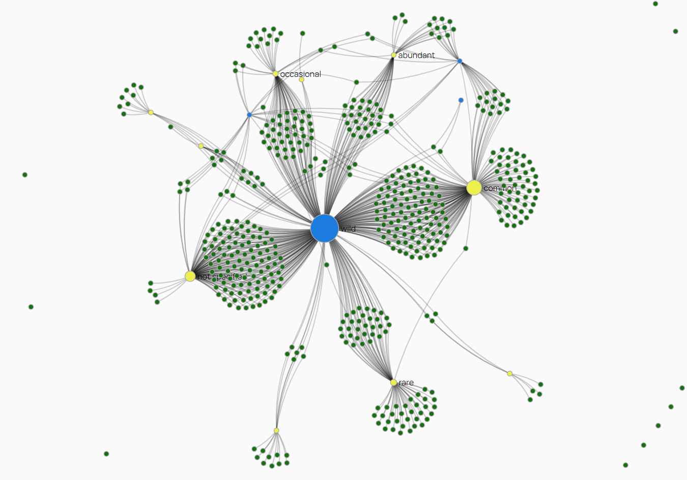
Visualization of the intersection of growth type (such as wild or cultivated) and prevalence in the Odessa region in 1890.
Perhaps it is a small thing to know where the buttercups grew around Odessa in the 1890s, but it is a powerful thing to be able to talk substantively about changes in biodiversity and the evolution of the built environment over time. In order to do that, the team is recording not only plant species but also the spatial vocabularies non-state actors used to describe the world around them. Tsarist bureaucrats might have seen southern Ukraine in terms of provinces and districts, but naturalists and farmers saw hillsides and coastal cliffs, flooded meadows and suburban kitchen gardens. It isn’t easy to put those places “on the map,” but that is an essential task if we want to truly understand historical space and its significance.
The research assistants at the helm — Davit Gasparyan, Jackie Erlon-Baurjan, and Olga Kiyan — are second-year REECA students. Here is what they have to say about their work-in-progress.
Kelly: When you aren’t poring over 19th-century botanical registers, what is your primary research interest?
Davit: My research interests are at the intersection of democratization, conflict resolution, and the European integration processes of former Soviet states.
Jackie: I am interested in how ecological context shapes ideas of time and place within Central and Inner Asia.
Olga: My research focuses on memory politics in the context of the Russia-Ukraine relationship.
Kelly: Okay, so what role, if any, does the concept of space play in your work?
Davit: I have found geography and cartography perfect complements to international relations and public policy. Maps in particular are modes of expressing the historical, geopolitical, and social realities I study; moreover, the spatial dynamics of social and natural phenomena mold local and international politics.
Jackie: My research resides at the nexus of the making of the nation-state, ecology, and violence. I am interested in what are often called "more than human histories" — histories that make use of conceptions of geography and space that allow us to see beyond the boundaries humans create.
Olga: I examine how memory and historical narratives have been utilized to formulate post-Soviet conceptions of identity in Russia and Ukraine. Given this focus, my own work underscores the destructiveness of imperial objectives, particularly the weaponization of historical narratives to subjugate identities and even deny them a right to existence. As a result, I am committed to understanding how the portrayal of the past, including the spatial dimensions of the past, informs the systems in which we exist today.
Kelly: The “Undoing Empire” project tackles a set of big methodological and theoretical issues related to historical space while diving into the weeds — quite literally — of plant life in southern Ukraine. What has struck you as interesting or challenging about your work on the project thus far?
Davit: I am motivated by the idea of deciphering and even decolonizing our knowledge of imperial Russia. The text we have been working on is a flora published by Petro Stepanovich Shesterikov in 1894. Shesterikov recorded his own observations of plant life in the Odessa region but he constantly referenced the work of other botanists. It doesn’t take long to get a sense of the network of rivals and peers — the text is peppered with critiques that range from skeptical to scathing. Creating a dataset from his work has pushed me to think about how to incorporate this critical, maybe even emotional, element of scientific knowledge into our data.
Jackie: I have never before worked in a setting where so much consideration is given to the process of data creation. We ask ourselves continuously how to digest the information and how to make it digestible by others. It has to be approachable. It has to be useful for trained specialists, whether they are historians or botanists. And it has to capture, accurately, what the source is telling us about an Odessa that no longer exists. Our source material is detailed but also inconsistent, so establishing a consistent set of attributes is not a straightforward process. Is it our job to code every detail? Should we make judgements about what is valuable or accurate? We are questioning everything.
Olga: I am interested in giving subaltern experiences a stronger voice. In this project our goal is to understand the geography of plants, and by extension the lives of the people who cultivated or destroyed or coexisted with them. To do that, we are identifying the local spatial vocabulary and organizing our data from that perspective. Shesterikov is constantly talking about habitats such as “the dunes along the coast of the Black Sea” or “the fields outside town” and we are experimenting with ways to recreate those spaces in GIS. It’s all about balancing what we can know with what we can’t quite know about the past.
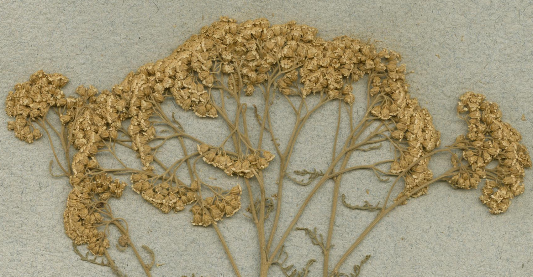
This Achillea L. was collected near Odessa (Odesa) in 1816. Image detail courtesy of JSTOR Global Plants.

Director of Graduate Studies, REECA Program, and Director, Imperiia Project, Davis Center
