

Ten years after Catherine II annexed Crimea, imperial officials undertook a survey of some of the most valuable properties in the newly-acquired territory: its gardens. The survey focused on orchards and vineyards that had been abandoned by their owners (Tatars and Greeks) and claimed as state property. The work was carried out between 1791 and 1793 and this dataset presents the results.
What do we know about the primary source?
The data comes straight from the State Archive of the Autonomous Republic of Crimea (after March 2014 it was renamed the State Archive of the Republic of Crimea within the archival system of the Russian Federation). The material is a set of reports describing state-owned properties in different regions of the peninsula, including river valleys and stream-fed enclaves on the southern coast. The reports are not consistent in terms of the kind of information recorded: some mention plot size and quantities of distinct tree varieties, while others simply attest to the presence of an orchard or vineyard.
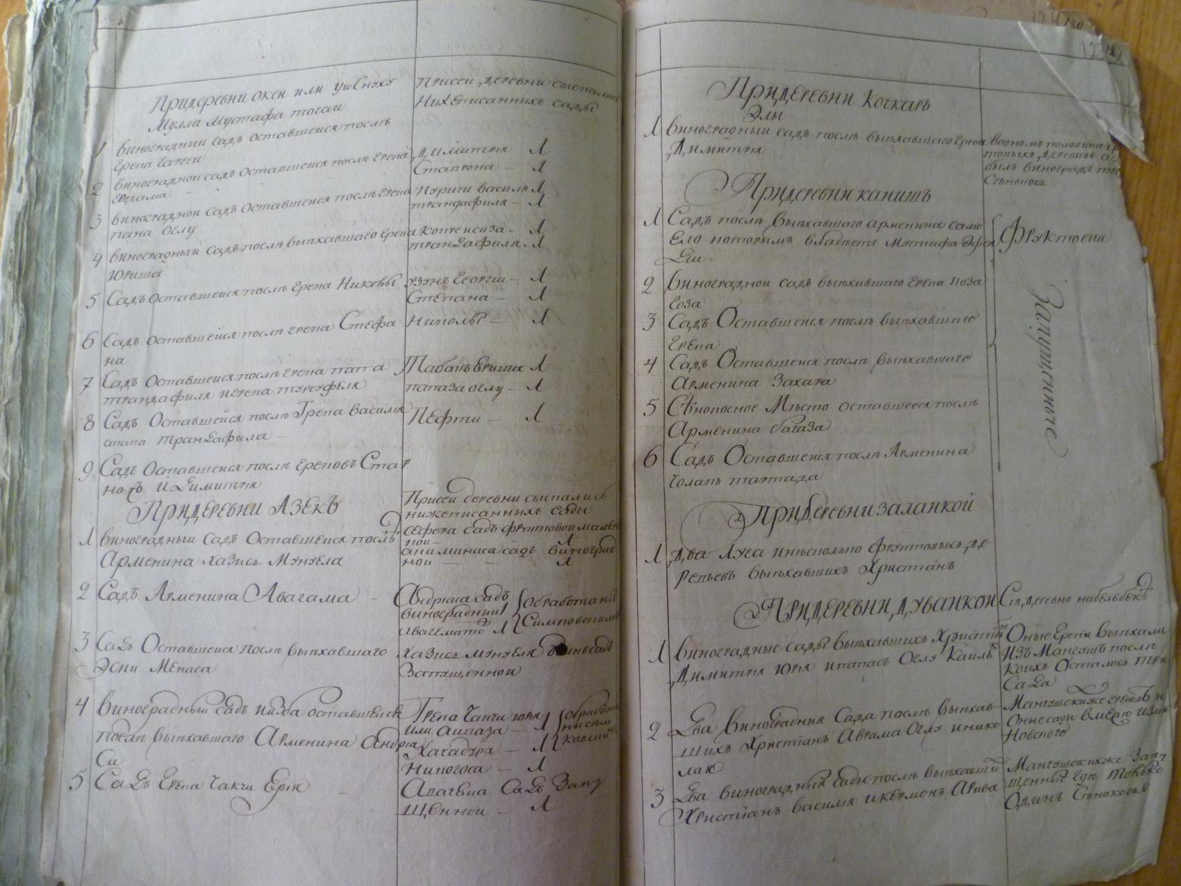
Sample page from the garden registers describing the southern coast in 1793.
What does the dataset contain?
"Gardens of Crimea" follows the typical Data Drive layout, containing csv files (data and metadata) and shapefiles (for those working with GIS software). How "big" is the data? It is a tricky question, but let's take a crack at it. You will find...
- 809 orchards and 332 vineyards
- 19,667 trees (plum! pear! cherry! walnut!)
- 214,571 grapevines
- 834 acres of garden space (about 631 American football fields)
How did we track down the locations of tiny 18th-century orchards?
The short answer? Magic.
The longer and slightly more responsible answer? We took two approaches. First, each garden is associated with a nearby village. Some of the villages are "lost" (due mainly to depopulation resulting from Stalin's deportation of the Crimean Tatars in May 1944) but many still exist. Almost all have been renamed. We used historical maps, historical gazetteers, and modern gazetteers to match places as they were in 1793 to places as they are in 2022. We provide a coordinate pair for each, either from Geonames or OpenStreetMap. Each coordinate pair represents the centroid of the modern settlement. In other words, we use a point on the map to represent a settled area.
This is a standard cartographic convention. But when it comes down to it, we all know that a town or village is a polygon, not a point. The same holds for an orchard or vineyard. And to make matters more complicated, the registers tell us that at Sudak, to take one example, there were 32 orchards and 30 vineyards. It makes little sense to represent all 62 with a single dot on a map. But the registers do not contain precise location information, and if officials drew up supporting maps, they did not make it into the archive.
These days, however, we have the luxury of drawing on OpenStreetMap, which is arguably the most powerful open source geospatial platform in the world. OpenStreetMap can tell us which nooks and crannies of Crimea are identified - today - as orchards and vineyards. The fact that a piece of land is a vineyard in 2022 does not mean it was a vineyard in 1793. This is true. But it is also true that the geography of garden space has not changed dramatically over the last two centuries: this is still a conversation about pockets of land watered by mountain-fed rivers and streams.
With that in mind, we matched past and present spaces as carefully as possible. We selected 62 modern garden spaces at Sudak to represent the 62 orchards and vineyards described in the registers. It is an art, not a science. It is an act of informed guesswork. It means that we cannot perform serious spatial analysis on the data. But the payoff is that we can visualize, in a schematic way, the distribution and density of all those pears and plums.
Looking for motivation to explore the data?
- Get a sense of the topography of Crimea. Pay attention to the aspect of the mountains and the directionality of the rivers and streams flowing from them. Take time to zoom in close and trace the contours of the southern coast with an eye to the garden locations.
- Dig into questions of change over time. Introduce contemporary data layers or georeferenced historical maps to gain perspective on the development of agriculture and urbanization.
- Put yourself in a gardener's shoes. Imagine you are the owner of a particular orchard or vineyard. Measure the distances to the nearest town or port. Does your property enjoy access to transportation networks? Does its isolation (or the opposite) work to its advantage?
- Use the information about previous owners to rough out the geographies of Tatar and Greek property ownership in the years prior to annexation. Which group owned more vineyards? Which group owned larger gardens?
View of the Tavrida National University Botanical Gardens in Simferopol

Director of Graduate Studies, REECA Program, and Director, Imperiia Project, Davis Center
